
Useful, Accurate Property Mapping
Technology has come a long way in the way forest land is mapped. At Long Meadow Resource Management, we use the latest Geographic Information System (GIS) technology to efficiently create accurate and useful maps for landowners. GIS maps are custom made for each client according to their needs to show trails, boundaries, natural features, historic items and/or other elements.
Customized, Shareable Maps
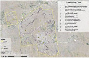
Many different types of maps can be made to suit a client’s needs. Property boundaries can be placed over aerial photos, contour lines, LIDAR (displaying detailed landforms), or historic maps. Global Positioning System (GPS) devices are used in the field to identify features, ground-truth maps and update management activity. Maps can be easily shared on paper, as PDFs, or as georeferenced digital files. To learn more about property mapping, please call us at (802) 658-2368, or use the contact form below.